Aerial photography
Aerial Photography
Welcome to our aerial photography section! We provide professional aerial photography services using modern drones and advanced equipment to capture high-quality images and videos from the air.
Our services include:
- Real Estate Photography: Capture stunning views of your property from a bird’s-eye perspective. This is the perfect solution for marketing and presentations.
- Construction Monitoring: Regular aerial photography allows you to track construction progress, providing accurate data for reporting and planning.
- Agriculture: Use aerial photography to monitor field conditions, assess crop yields, and identify problem areas.
- Cartography and Geodesy: Create accurate maps and terrain models for various projects.
- Events and Occasions: Capture unique moments of your events from the air, creating unforgettable memories.
Why choose us:
- High Quality: We use advanced technology and equipment to capture clear and detailed images.
- Experienced Team: Our specialists have extensive experience in aerial photography and are ready to handle projects of any complexity.
- Personalized Approach: We consider all client wishes and offer solutions that best meet their needs.
- Safety: We strictly adhere to all safety rules and regulations when performing aerial photography.
Aerial photography of the area is an effective and affordable way to get a map, a topographic plan, examine communications, power lines, calculate the most optimal options for land development and solve many other problems.
Aerial photography allows you to process large areas, digitize objects, obtain data on the height and boundaries of the site with a high degree of detail.
Contact us to learn more about our services and discuss your project. We are happy to help you bring your ideas to life with aerial photography!
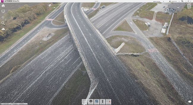
An example of a point cloud in rcp format.
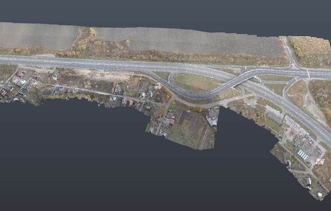
The shooting was carried out from a UAV at different heights.
Using a UAV, you can get a fairly dense point cloud that can be used in various engineering and architectural projects.
This point cloud can be used in conjunction with mobile or stationary scanning. The use of stationary or mobile scanners significantly improves the detail and accuracy of the point cloud.
More details at the link
Get Service
Home Menu
Service Menu
OUR OFFICE
st. Bratislavskaya 14-B, office 7
Tel: +380673831972
Tel: +380504003900
Email: 3dscan.ua@ukr.net